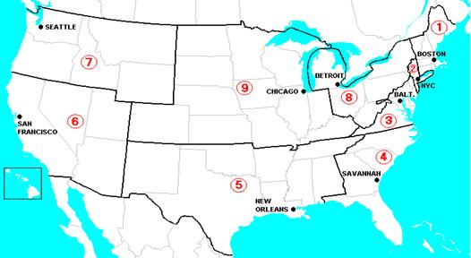
1922 USA Callsign Map
Above is a map of the nine U.S. Radio Inspection Districts, adopted from a map which appeared on page 55 of the July, 1922 issue of Radio News. (The layout of the districts reflected the early emphasis on radio's use by seagoing vessels).
1. BOSTON, MASS.: Maine, New Hampshire, Vermont, Massachusetts, Rhode Island, Connecticut.
2. NEW YORK, N. Y.: New York (county of New York, Staten Island, Long Island, and counties on the Hudson River to and including Schenectady, Albany, and Rensselaer) and New Jersey (counties of Bergen, Passaic, Essex, Union, Middlesex, Monmouth, Hudson, and Ocean).
3. BALTIMORE, MD.: New Jersey (all counties not included in second district), Pennsylvania (counties of Philadelphia, Delaware, all counties south of the Blue Mountains, and Franklin County), Delaware, Maryland, Virginia, District of Columbia.
4. SAVANNAH, GA.: North Carolina, South Carolina, Georgia, Florida, Porto Rico.
5. NEW ORLEANS, LA.: Alabama, Mississippi, Louisiana, Texas, Tennessee, Arkansas, Oklahoma, New Mexico.
6. SAN FRANCISCO, CALIF.: California, Hawaii, Nevada, Utah, Arizona.
7. SEATTLE, WASH.: Oregon, Washington, Alaska, Idaho, Montana, Wyoming.
8. DETROIT, MICH.: New York (all counties not included in second district), Pennsylvania (all counties not included in third district), West Virginia, Ohio, Michigan (Lower Peninsula).
9. CHICAGO, ILL.: Indiana, Illinois, Wisconsin, Michigan (Upper Peninsula), Minnesota, Kentucky, Missouri, Kansas, Colorado, Iowa, Nebraska, South Dakota, North Dakota.
The FCC regrouped the states into different callsign districts in 1946. You could not request a call sign in those days. Many hams lost their calls. Some were able to keep their calls but change to a different number.
Courtesy of W8CXO